
Cactus and view up the valley from San Sebastian along the GR131 and 132
6 PM on top of the 604 m high mountain with a view to Hermigua on the ocean. The 4WD road we will take down the 400 m high cliff is closed by a gate, many trees block the road and it is also damaged by land slides. At 7 PM it will be pitch dark, still 2-3 hours to go to Hermigua.
La Gomera has 2 marked, with read and white stripes, Grand Routes, the GR131 and GR132, see overview map [1] which is hard to get as it cannot be bought on La Gomera. Quadrants: NE, NW, SW, SE. The GR131 is shorter as it stays higher up the island and can be done in 5 or 6 days. The GR132 is longer, possibly 9-10 days, and has more up and downs of 500 to 900 m, staying close to the steep coast. Buses can be used to shorten the routes as the trails stay relatively close to the main roads. We did a mix of the 132 (first and fifth day) and 131 (second to fourth day) in five days.
San Sebastian
When we arrive in San Sebastian by the smaller ferry from Los Chistianos, very few passengers get off, most carry on to Val Gran Rey which is a large holiday resort. We stay at the Parador.
The Spanish invaded the Canary islands in the early 15th century, obliterating the original North-African farming population within decades by enslaving them. Columbus lived in San Sebastian which has a Columbus museum. Here he observed the dominant wind direction, Easterly in the winter and Westerly in the summer. From this he argued he could sail to the West, or "China", and come back. Their is a Columbus museum in San Sebastian.
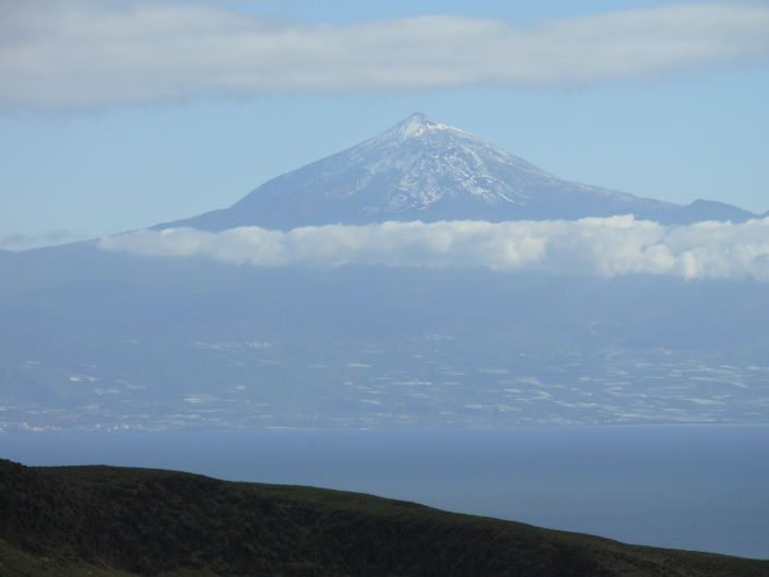
The GR132 trail from San Sebastian to the forest road slowly goes up and stay just below the highest ridge, the Jaragon at 642 m. We have a constant view at the Teide volcano of Tenerife.
Teide volcano on Tenerife, view from La Gomera.
The map tells you to go up at a black lava side valley, also indicated by a big cairn but we did not see a trail so we continued along the contour lines. A black plastic water pipe goes up the hill and joins the trail leading to the forest road at La Gerode. It is a good marker once you loose the trail.
The trail continues on the steep south side of the ridge 100 m below the shepherds houses with the barking (but not biting) dogs.
Trail below the ridge (top right) to the forest road at the saddle (top left, light green and brown).
The navigation took a lot of time as we lost the trail. Other walkers seem to have the same problem, including a German girl, Beate, on her own. She wanted to go to the Casas de Cuevas Blancas near the coast with a view at Tenerife. She stopped to help us as we seemed to be lost visible from a large distance by the swinging walking stick in the discussion. We dismissed her directions at a steep, poor trail down (which was a difficult route down but suitable for us and sheep [1]) and thought the trail would lead across the top but here we ended up on a high cliff [1] and had to go back.
Black water pipe at the key turn off to the forest road (view to San Sebastian).
Very steep trail down to the main trail. Forest road to Las Cassetas in the far distance.
She decided to cut it short as it was already late and took the forest road down to Las Cassetas and hitch-hike back to San Sebastian.
Pass and high cliff, view from the forest road to Hermigua. Trail to the forest road below the cliff on the far right side.
Same cliff, with Beate.
At 3.30 PM finally on the forest road and 3 or 4 more hours to Hermigua on the first day we contemplated what to do as it gets dark at 6.30 PM. My travel companion had, as he calls it, an "excruciating" pain, a left bottom foot tendon that gave up after carrying 103 kg on a beach walk a few weeks ago. A forest road all the way should be easy, even when it gets dark. Unfortunately I miss-calculated the scale of the map by a third, a square was 2 km, not 1.5 km.
The road is endless and we seem to walk slowly but steadily. Curve follows after curve and the road is wet and muddy in places. A thick, light brown water pipe along the road will stay with us until Hermigua we hope.
After 2.5 hours, at 6 PM, we are finally on top of the 604 m high mountain with a view to Hermigua on the ocean. Local road workers clearing the road of trees already warned us that the 4WD road we will take down a 400 m high cliff is closed as trees block the road.
Hermigua with a view at the 600 m high ridge with the 400 m cliff we took down using the dirt road blocked with trees, far left in the background.
We climb over the corrugated sheet fence that blocks the road, and hit the first jungle of trees. The dirt road is now a zigzag trail along and underneath fallen trees on side of the 400 m high cliff. It also has numerous wash outs and big holes due to land slides but luckily a rough trail has been cut open. After 30 minutes going down, the road is finally clear of trees but it is getting dim and the dirt road still has tricky wash outs.
Dirt road going down, finally clear of trees.
At 7 PM we reach a junction with a local dirt road and now the road is fine but water pools are difficult to see as it is pitch dark. I use the 2 inch LCD screen of the Nikon L1 camera as a torch and this does work less than more, and is not ideal.
In the distance we see car lights and hope for a ride, still 6 km to go. The 4WD car with two “pastores de cabra”, goat shepherds, stops and they asks us if we want a ride. Another 50 minutes in the car on a wet dirt road takes us to Hermigua. I am sitting in the back luggage area between two dogs, not very comfortably on a gasoline jerry can and something of metal but it beats walking in the dark. They drop us of in in Hermigua. It is now 8 PM, we saved 6 km of walking in the dark.
Net walking time today 8 hours, saving 1.5 hours by a ride. Temperature 20 Celsius at 700 m.
The red and white signs of the GR132 were visible along the forest road but the trail map at Hermigua on the “playa” clearly tells you to join the GR131 South of Las Cassetas. This crosses the mountains near the car tunnel reaching the main town of Hermigua inland. Estimated walking time is 3 hours, 2 hours less than the 5 hours of our route.


![[1]](05gomera1064mapoverview.jpg)