
Highland Cows in the lake between Parnassia and the view point (“Hazenberg”). View towards the West.


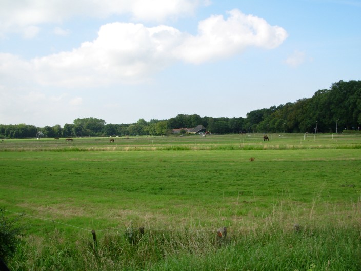
Pond in low and wet area near the coast and horses, NE part of the park.


Highland Cows, North part of the park. White fluffy calf, near Parnassia.
Can you still see something that resembles nature in Holland or is it just a cultured landscape? All the pristine forests are definitely gone, turned over several times since the Iron Age 4000 years ago.
Artificial nature with large animals like deer and horses has been created at the Oostvaarderplassen in Flevoland but this is off-limits to the public. De Veluwe in Central Holland still has deer and wild boar. Unfortunately, it is a long way from Amsterdam, and when you walk or cycle around, the large animals hide for the numerous day-trippers.
The coastal dunes on the North Sea coast are unique to Holland. This 1-8 km wide strip of sandy land on the coast is partially forested and has a unique flora and fauna. It runs along the entire coast of mainland Holland with only a few interruptions by cities, harbours or farmland. In the North, they form barrier islands called “De Wadden Eilanden”.
Close to Amsterdam, within 30 to 45 minutes by train, are the dunes West of Haarlem, West of Castricum, and West of Alkaar.
My favourites are: (1) the Kennermerduinen Zuid, North-West of Haarlem, mainly because of the numerous up and downs with an elevation difference of up to 20 m and the big animals like horses and cows; (2) the Waterleidingduinen, South-West of Haarlem because of the empty beaches and reserved for walking only; no cycling, so there are relatively few people; (3) West of Castricum as it is relatively quiet; and (4) West of Alkmaar near Bergen as it is also relatively quiet.
Further away from Amsterdam, there are large sections of dunes with relatively quiet beaches at Voorne which is South-West of Rotterdam (apart from a small concentration of windsurfers), West of Wassenaar, and on the Wadden Islands in the North of Holland. Sections at The Hague, Katwijk, Noordwijk, Zandvoort and IJmuiden are extremely crowded.
The Kennemerduien Zuid are located North-West of Haarlem and have several gates which are close to the stations of Haarlem Overveen (South-East entrance, 15 minutes), Bloemendaal/Santpoord Zuid (middle East entrance, 15-20 minutes), or Santpoord-Noord (two North-East entrances, 5-10 minutes).
Given the numerous trails in this area you do need a map, see below for a copy. Alternatively, you follow the marked NS route from station Haarlem Overveen to Driehuis, a 20 km walk, and you could have lunch at the restaurant/terrace Parnassia on the coast after 1.5 hours.
My favourite is to start at the Santpoord Noord NW or SW entrance and take a round tour, passing the estate (or castle) of the “Vrienden van Jacob”, the Duinmeer, the Parnassia terrace, the Vogelmeer and the Oosterplas (a lake for swimming). You could end at the Bloemendaal/Santpoord South exit, taking the train back from the station at Bloemendaal or Santpoord South. The total distance is about 20 km and this takes you 3.5-4 hours net walking time, not counting rest breaks at the many viewpoints or benches which add another two hours.

Map with the route marked with a red line. Click on map to enlarge. (Higher resolution map but no route)

Google Earth view with the route and the distance, total distance almost 18 km.
Leaving the Santpoord Noord station you follow the road to the SW and after 300 m there is a farm converted to a bar/ terrace with ice cream, soft drinks and precious cappucino. This is a favourite place for day trippers on bicycles. The SW entrance (relative to the station) to the park is here [1].
Farm terrace with good cappuccino. View from near the Santpoord-Noord station, also see [detail]

Same, view from the road.
At the Santpoord Noord SW entrance [1] of the park you have several choices to go to the beach. The shortest route is due West and after 6-7 km you are already on the coast but this trail starts with only a 2-3 km forest walk and then follows a bicycle lane for the remaing 4 km which tends to be popular by cyclists, especially on warm summer days.

Detail of castle, visible from the road, also see overview [1] and the garden [1] [2].

Castle
A more scenic route is to go North following the ice cellar route that starts at a parking lot [entrance] [sign] along the edge of a 19th century estate, the “Vrienden van Jacob”, visible through the trees [1]. This is a five star resort hotel for business meetings but also has a restaurant with a single Michelin star, see [Vrienden van Jacob]. The restaurant is closed on Sunday night. You need to book a table a few weeks in advance as it is popular with the local gourmet types living in Bloemendaal and Santpoord.
You pass an old ice cellar built in a hill [1], that was used as a large refrigerator in the 19th and early 20th century. It was filled with ice cut out of frozen ditches during the winter.
The trail winds through a hilly landscape lined with various trees [1]. The beech trees on the estate are impressive with their green, smooth bark. They create large open spaces underneath by taking out the light by the wide branches with a dense cover of round leaves. During heavy rain, beech trees are ideal as a shelter holding off the rain the longest of any tree.
Alternatively, you could walk straight to the castle from the Santpoord-Noord station. It is a good spot to have a quiet lunch on the terrace which has a wide view across the estate. To pick up the North route described above, you need to jump across the low iron gate (easy) at the entrance of the castle [1]. This is not an official entrance but nobody will stop you and the gate is strong.
The trails goes further North through a forest across a winding up and down trail with an altitude of even 20 m at the highest point [1]. Here there are also many large pine trees [1]. Down the hill, the forest clears and you now go through meadows with Icelandic horses [1] lined with low bushes [1]. You also pass a large area with wild blackberry bushes, which are edible in early August [2]. This can be a very popular spot [3] with black berrypickers forcing through the thorny bushes to find the best berries [1].
After passing a cattle gate [1] you are close to the Santpoord-Noord NW entrance. Here there is a small parking lot. This entrance could also be reached directly from the station by going North along the rail-road tracks.
You could also make a detour to the Driehuis cementary going back to the main road but my route goes due West following the NS route marked with white/red labels. The cementary is fenced off and from the forest road you will have to climb a 2 m high fence to enter it which is not advisable.
At the Driehuis cemetery the third political murder victim, Pim Fortuin [1] [2] , in the history of the state of the Netherlands has a second grave or memorial. His official grave is in Italy at his former country house.
William of Orange in 1584 was the first in our history. The Spanish King put a price on his head for helping to liberate the Dutch provinces and after several attempts finally someone managed [see description]. In those days politics and successful business was often related and William of Orange did not do to well until the uprise of the Netherlands against Spain and associated war booty. His sons, Maurits and Frederik Hendrik, got very rich during the subsequent 80 year war with Spain.
The second (double) murder were the De Wit brothers in 1672. They were killed by an uproar of common people but this was initiated by politicians who wanted to dispose one of the de Wit brothers who was the regent or administrative ruler of Holland.
Pim Fortuin was a populist, according to foreign newspapers, and his followers were called “fortunists”. Dutch media have a mixed opinion and common people in Holland are still not sure. He is still very popular in Rotterdam, the harbour city of Holland.
At the Santpoord-Noord entrance the route starts in a forest and here there is a single private house. After a few km you reach a bicycle lane and an old water infiltration canal for drinking water. Now the landscape changes to hilly grassland and low bushes [1] [2] with occasional patches of forest [1]. This will remain so until the coast. When you are lucky, like on cool rainy winter day, you may see deer, rabbits or fox.
The forest along the canal is a favourite spot for Highland cows. They also stand in the canal during warm summer days [1]. Highland cows are fully self sustainable and live here year round. They are the gardeners of the dunes.

Cows at the old infiltration canal.
They are very popular as landscapers in natural parks as they create an open the landscape by destroying trees and bushes, just like the horses, sheep and cows did during traditional herding on the moors and in the forests in Holland over the past 4000 years. Without cattle, the grassland and low bushes in this park would quickly turn into dense forests, probably within a 100 years.
After about an hour from the Santpoord Noord entrance and at the junction with the “Wittenweg”, there is a scenic, sheltered, but very popular bench under large pine trees. Except on very warm days of 28 plus Celsius, when most walkers stay out, it is always occupied and the occupants seem to have long conversations.

View at the large trees [1] and popular bench, view East.
From here it is another hour to the coast along an old 4WD trail, along the “Koningsweg”. The track is not maintained any more and can only be used by walkers although you do meet the occasional illegal bicycle ploughing through the lose gravel and sand. There are two other side trails, the “2e Dwarsweg” and the “Olmenpad” that go South West to the bicycle lane on the “Zeeweg”. The NS route turns off at the “2e Dwarsweg”.
A scenic stop over for a rest is the “Duinmeer” lake [1] after about 40 minutes from the scenic bench. This has a bird watching shelter [view from] [shelter] [shelter]. It is also a favourite spot for Highland cows and horses as it is well sheltered. A few 100 m past the bird watch shelter turn-off, there are animal trails to the lake (lake is visible from the main trail) but this is off limits to the public. You also run the risk of being bitten by tics on wet days.
The lake has large fish [1]; You may also see a herd of horses [1] with a dominant stallion [1].

Highland cows at the bird watching lake, the “Duinmeer”.

Horses at the bird watching lake, the “Duinmeer”.
Near the coast there is a bicycle parking lot and this is the end of the “Zeeweg” bicycle lane. To reach the coast you cross the dunal barriers, a 15-20 m high ridge. The loose sand is heavy walking but the view on top pays off. My favourite is “who is first on top by running uphill”.
This part of the beach is relatively busy during warm summer days. There are nice sheltered hiding places in the wide dunal area, protecting you from the constant wind that blows in sand and takes the view off the beach crowd.

The coast at the North entrance to the beach, view North to the pier of IJmuiden.

The coast at the North entrance to the beach, view South to Zandvoort.
On the beach there are large plastic bins made in the shape of chess pieces [1] .

Garbage bins modelled in the shape of chess pieces.
You will also see brown “hares” standing in the dunes. They can be motionless for tens of minutes at the time waiting for an “approach” [Brown "hares"].
The terrace and restaurant Parnassia is another 30 minutes South along the wide beach. In the far distance you can see the high rises of Zandvoort. In August there are outside disco parties at Bloemendaal aan Zee, which is in between Parnassia and Zandvoort. In the past you could hear the boom-boom bass of the disco parties drifting for kms along the beach but this is now banned. Bloemendaal aan Zee remains the place to be for the “young and beautiful” people.
The Parnassia terrace can be very crowded during warm summer days but a visit always pays off as the food is reasonable, resembling an Alpine ski restaurant for lunch. You could also just fill up your water bottle and use the toilets (50 Euro cents).
Parnassia can be reached by car during normal summer days of 19-21 Celsius but when the temperature rises above 21 Celsius it is extremely crowded and the access road from Haarlem blocked by traffic jams. Many young people don't mind, they set the car stereo very loud and are already at a party, especially when they have a cabrio.
You could avoid the crowd at Parnassia by taking a short-cut at an earlier coastal entrance after only 500 m from enterin the beach and go SE along a very quiet trail to the Vogelmeer, see map above and below for continuation.
The route goes due East, following a stone bicycle lane initially. It turns left after some 500 m towards a view point called the “Hazenberg” [1] [2] , the highest point in the area, clearly visible from the bicycle path by a typical fence on top. On Sundays, you may hear the distant roar of engines of the Zandvoort racing circuit.
This area is very busy with walkers and bicyclist but they tend to avoid the view point as it is a bit of an effort to reach it.
Between Parnassia and the view point, low areas in the dunes were dug out a few years ago to create wet areas resembling natural salty lagoons. These used to be common along the coast but have been removed over the past 500 years by extensive coastal defence systems. They are now created to attract the original, more mixed vegetation and wild life.
In the winter and early spring the lake is usually filled with water. Highland cows can be seen here and when you are lucky in the spring, a white calve [1].
Highland cows in the lake between Parnassia and the view point. Lake has water in the winter.

Highland bull at the lake the view point.

Highland cows between Parnassia and the view point. Lake is dry in the summer.
The cows are not dangerous, look very calm, but one should not come too close as they may be protective, the female guarding a calf and the bull guarding the herd. Mature bulls are rarely seen, possibly taken out by the National Park as they may not always be friendly.
From the viewpoint, Parnassia is also visible in the far distance across the low area [1].

Parnassia, detail. Note the many boats at the horizon (click on picture to enlarge) waiting for entering the Amsterdam harbour after the weekend.
To the East side, the viewpoint has a view at the Vogelmeer [view North-East] [view East] . Most people do not stay long at the view point and there are perhaps 2 to 4 other people at the time. It is a nice spot for a rest on one of the benches.
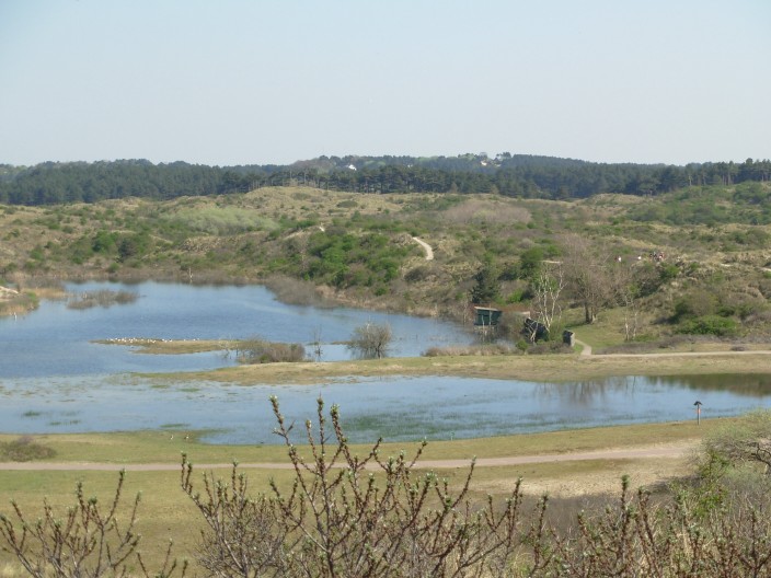
Vogelmeer with a birdwatching shelter. View from the viewpoint at the “Hazenberg”.
The Vogelmeer has been been changed recently by landscaping [1].The water level is now higher and the shores flooded more often. Some of the shores were also dug out to enlarge the lake. It has lots of birds and these can be watched at a close distance from the shelter on the South side [1].
By that time I get here, I tend to feel like walking on, also to avoid the crowd as this area is very busy with cyclists and walkers being close to Parnassia, even during cooler days. From here it is still at least 1 hour and 15 minutes to a station.
An alternative route is to go to the Haarlem Overveen station towards the South-East..You would pass “De Koevlak”, a large lake also used for swimming.

Cross on the hill above the cementary.

Cementary.
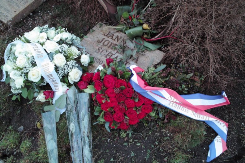
Grave of Hanny Schaft.
My regular route is to walk South and East along the Vogelmeer and NE to the Oosterplas, a swimming lake, which is another 45 minutes. At the Vogelmeer NE tip you pick up the SE short cut from the beach described above that avoids the Parnassia crowd, advisable during busy summer days.
The route goes along a 4WD trail through a forest with large pine trees [1] [2], alternating with open areas [1]. Half way there are two scenic benches rather close together for a rest [1] [2] and it still 4 km or less than one hour to the station. This route is again quiet. Starting at the second bench there are many ways to go on but you should follow the yellow route East to the Oosterplas [1]. You pass another lookout point but here the views are not special [1]. Another 10 minutes, first going down a sandy trail, [1] and at a junction of trails [1] you turn left leaving the yellow trail and you are at the Oosterplas. This is a very refreshing spot for a swim after a 3-4 hour walk. When it start raining, there are pine or chestnut trees [1] for shelter.

The lake is 300 m long and 200 m across [1]. In the late summer, the water may get too warm and the lake could have algae growth so it is not advised to swim in those conditions.

South side of the Oosterplas, a quiet swimming spot.
The North-East side is very crowded with families [1] [2] [3]. They reach the lake by bicycle or walk 10 minutes from the parking lot at the Bloemendaal/Santpoord Noord entrance. The South side of the lake has the fewest people as you need to take a rough sandy path from the North-East side to get here.

Highland cow and Nile geese
On rainy days there are no visitors and you may see Highland cows and Nile geese [1].
The only other lake for swimming is the Koevlak which you reach on the route from Parnassia or this lake to the station Haarlem Overveen. This lake is much larger but also more crowded.
From the Oosterplas it is another 25-30 minutes to a station going through a pine forest [1] [2]. Past the Bloemendaal /Santpoord Noord entrance (“Ingang Bleek en Berg”), which has a large paid parking lot, there are hocky and football fields. You should go through the stone gate [1] and use the short walking lane between the hockey and football fields, not the long asphalt access road, to go to the main road, the “Brederolaan”.
The nicest route is to the Bloemendaal Station but the route to Santpoord-Zuid takes you through a nice forested villa area.
From the main road on the Brederolaan [houses on a side street] it is one km or 15 minutes to station of Santpoord Zuid [1] (follow the Duinlust-, Pinel- and Vinkenlaan to view the villas and mansions) and 20 minuten to the Bloemendaal station (Brederolaan South, Donkerelaan, Kerkplein, Noorderstationsweg). You pass many villas [1] and even mansions in a forest setting on e.g. the Vinkenlaan. My favourite house is an old farm house made of wood, “De Zandhoeve”.

De Zandhoeve in Santpoord- Noord in the villa area.
At the Kerkplein in Bloemendaal there are two good restaurants and nearby you will find one or two more bars and restaurants but these could closed on Sunday during the winter.
Around the station in Santpoord-Zuid bars or restaurants are totally lacking. There is only a single snackbar with a small terrace. A discount gas station taking up a hectare of space destroys the nice view.
Once you are at a station, you will be tired. This was a long trip, some 4 hours net walking time. The train to Amsterdam leaves at 5 minutes past the half hour from Santpoord Noord and a few minutes later from Bloemendaal.
You will not see the Zandvoort crowd, generally not even in Haarlem as they take a different train.
Surprizing how easy you could do a nice day walk by taking a train from Amsterdam, see some nature, visit the beach and avoid the beach crowd. Total distance is 18 km.
There is still some nature in Holland but it has been landscaped.
You are visitor # since August, 2007.
![[1].](07ne3588entrance.jpg)
![[detail]](07ne3572farmterrace.jpg)
![[1]](07ne3586castle.jpg)
![[1]](07ne3604gardencastle.jpg)
![[2]](07ne3582gardencastle.jpg)
![[entrance]](07ne3598route.jpg)
![[sign]](07ne3601icecellarroute.jpg)
![[1].](07ne3609castle.jpg)
![[1]](07ne3605icecellar.jpg)
![[1]](07ne3614beechtrees.jpg)
![[1]](07ne3533gate.jpg)
![[1].](07ne3531trail.jpg)
![[1]](07ne3619pinetrees.jpg)
![[1]](07ne3636horses.jpg)
![[1].](07ne3543path.jpg)
![[2]](07ne3628berries.jpg)
![[3]](07ne3630berries.jpg)
![[1].](07ne3623berries.jpg)
![[1]](07ne3632gate.jpg)
![[1]](09ne_dunes3649pim.jpg)
![[2]](09ne_dunes3643pim.jpg)
![[1]](07ne3544path.jpg)
![[2]](07ne3547dunes.jpg)
![[1]](07ne3551bench.jpg)
![[1]](07ne2682cow.jpg)
![[1]](07ne3653duinmeer.jpg)
![[view from]](07ne3645duinmeer.jpg)
![[shelter]](07ne3648duinmeer.jpg)
![[shelter]](07ne3649duinmeer.jpg)
![[1]](07ne2702fisch.jpg)
![[1]](07ne2711horses.jpg)
![[1]](07ne2709stallion.jpg)
![[1]](07ne3664bins.jpg)
![[Brown "hares"].](07ne3656hare.jpg)
![[1]](07ne3667viewpoint.jpg)
![[2]](07ne3671viewpoint.jpg)
![[1]](07ne2727calf.jpg)
![[1]](07ne3679parnassia.jpg)
![[view North-East]](07ne3673vogelmeer.jpg)
![[view East]](07ne3677vogelmeer.jpg)
![[1]](07ne3684vogelmeer.jpg)
![[1]](07ne3682vogelmeer.jpg)
![[1]](07ne3685route.jpg)
![[2],](07ne3688route.jpg)
![[1]](07ne3694openlandscape.jpg)
![[1]](07ne3691bench.jpg)
![[2]](07ne3698bench.jpg)
![[1]](07ne3697junction.jpg)
![[1]](07ne3699viewpoint.jpg)
![[1]](07ne3701viewpointdown.jpg)
![[1]](07ne3704junctionoosterplas.jpg)
![[1]](09ne2390herbert.jpg)
![[1]](07ne3711oosterplas.jpg)
![[1]](07ne3710oosterplas.jpg)
![[2]](07ne3713oosterplas.jpg)
![[3]](07ne3718oosterplas.jpg)
![[1]](07ne3721oosterplasroad.jpg)
![[2]](07ne3723routelast.jpg)
![[1]](07ne3724hockyclub.jpg)
![[houses on a side street]](07ne3729reetroofs.jpg)
![[1]](07ne3737station.jpg)