
To Newfoundland
Table of Contents of "To Newfondland"
*
To Newfoundland
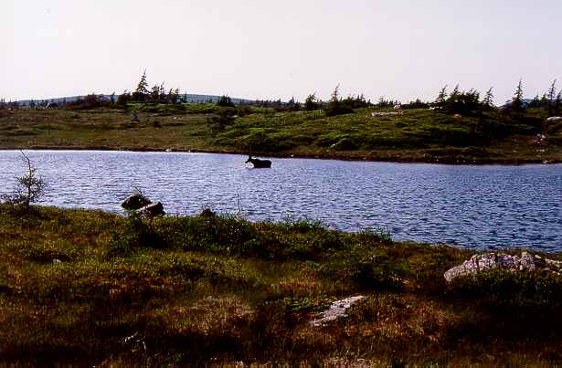
Spending several months in the mountains of Newfoundland in Eastern Canada is fairly special [1]. The partially barren highlands are very pristine, with virtually no inhabitants but full of original animal life (e.g. moose, cariboes, bears and foxes), very few roads and the only tourist activity are the sparse fishing cabins. The resemblance to Alaska is striking. This is how Scotland could have been if nature would have been preserved.
In 1985 I started a research position at the Geological Survey of Canada in Ottawa with the task of doing three seasons of three-month of field work in the summers of 1985, 1986 and 1987 in the Southern Long Range Mountains. This involves camping in the mountains and being moved around by helicopter as the only dirt road in the area gives very little access.
Newfoundland has a rich history. The first European settlers were French, Spanish and English fishermen in the 16th century and due to the dominance of the French in the 17th century many geographic names are still in French. Already 5 or 6 centuries earlier the Vikings discovered Newfoundland from Greenland and there are archeological sites in northeastern Newfoundland. The Indians living in this area were treated very badly. They were hunted and put in prison camps in the 18th and 19th century with the aid of Mikmak Indians of Nova Scotia. European diseases and poor living conditions in the camps ensured that the last native Indian died in xxxx (early 20th century).
For more information of this region see e.g.:
http://www.durham.net/~kburt/NewfoundlandHistory.html
http://web.cs.mun.ca/~dylan/links/history.html
The area is mountainous with interior highlands of the Northern and Southern Long Range mountains at 500-700 meters altitude. On the East Coast the terrain is cut by fiords, including the giant Grand Lake, an old land locked fiord.

On the South Coast there is a permanent summer fog formed by the cold Gulf Stream off the coast. Here most of the fishing hamlets are centuries old, still having the small wooden houses and can only be reached by the bi-weekly postal boot.

In the mid-eighties both cod fishing and seal hunt were down. Cod due to overfishing and too many seals that spread worms in the fish-seal cycle, cod would eat excrements of seals and seals eat the cod. The large numbers of seals used to be controlled by the yearly baby seal hunt until Green Peace had a successful action banning baby sealskins. In 6 weeks a seal hunter could earn 12000 dollars, a huge income for them. However, the rough fisherman were obliged by law to club the baby seals twice in the head to ensure they were dead but due to the rush in catching as many as possibly they would not do. This gave Green Peace a chance to take bloody pictures of living baby seals with blood stained heads. Now the government has a yearly quota shooting seals to keep their numbers down. Seals in this area have natural enemies like killer whales and sharks and you wonder why the government insists there is no natural balance. Is it economic as the fishermen artificially try to increase the abundance of cod by killing seals?
August is the best month to visit Newfoundland bug wise and weather wise. June and July can be very wet, with weather systems passing by every 3-4 days resulting in a full day of rain and humidity of a 100%. Even within the tents we might have to cover up the sleeping bags with a plastic tarp as the 100% humidity formed a mist in the tent wetting the sleeping bags.
Summer of 1985
In the summer of 1985 I visited Newfoundland for the first time. End of May we went by car from Ottawa to Sydney in Eastern Nova Scotia, a two-day and 2000-km ride. In Sydney we took the overnight ferry to Port aux Basques and the crossing was rough and cold in the late spring. From Port aux Basques we took the road to Corner Brook, the main town in Western Newfoundland. Outside Port aux Basques near Table Mountain, you drive along the barren coast and here the old cross Newfoundland railroad starts that runs to Saint Johns on the East Coast, a track of some 600 km but this is not used anymore. This area is known for its heavy winds and several times a year the road can be closed. The railroad was built in the 19th century and the track is not particular straight as the builders got paid by the km. They choose to use narrow track rails which was not a good choice in this windy area and the train has turned over a few times by the heavy wind.
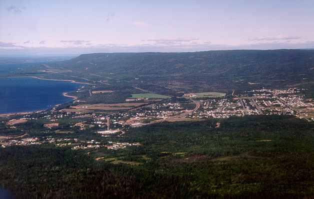
Our base camp was in the village of Pasadena just passed Corner Brook on Deer lake, in a cottage camp of the Forestry Department [1][2]. The helicopter base of Viking Helicopters [1] is also located here that would drop us in the mountains and do the camp moves every week of the three 2-person fly camps. We had a budget of some 140 flying hours for three months.
Scotty [1], the chief pilot of the base, was from the Orkney Islands but he stayed here after marrying a local girl, the daughter of the supermarket [1] storeowner of Pasadena. He was my favorite pilot, could do anything with his Hughes-500D helicopter. I had him once lowering the helicopter in a hole of a canyon vertically to get some samples or touch the steep lake side of Grand Lake with one leg while the engine was on full power, a kind of hovering, to let us out. This type of helicopter was 50% faster and powerful than the Bell 206 I was used to in Northern Canada but the hourly rate was also 50% higher, around Can$ 500 per hour. They were used for the first time in Vietnam for reconnaissance missions and their speed and maneuverability made them very popular. The helicopters already had a GPS system crucial for finding seal fishermen and boots on the sea but it was also handy during rainy and low cloud weather. After punching in the coordinates, you could easily fly to the proposed camp. I once did this in heavy rain with the mountains covered up in the clouds but we easily found the new camp marked on the map by zigzagging through the mountains, watching not to hit a mountain.
Our first camp was near Fishels Brook, next to the large Anorthosite outcrops that formed a rough terrain of rocks and low bush [1][2], the infamous tuckamore [1], a type of Arctic spruce that grows to two-meter height and is very tough.
We quickly found out that walking around in this wild terrain [1] requires bush skills. You would always try to follow the animal "highways" [1][2][3], clearly marked age-old trails cut out by the moose, cariboes and bears. The trails tend to take the easiest route, not necessarily the shortest. With the aid of detailed aerial photographs, you could spot the numerous light-colored bogs, semi wet peat marches [1], or open rocky terrain among the tuckamore bush [1] and there would always be a path in between. Similarly, a passage between lakes would also have a trail. Leaving a path was not a good idea as you would end up in the thick bush of the tuckamore and walking was impossible. If there weren’t animal trails between open spots, the reason would be the terrain: too steep. Don’t even try it.
I preferred camping on a lake [1][2] but generally you would have to settle for small open spots nearby. Often you would have to pitch the tents on animal trails but we tried to avoid this [1] for a good reason. This could give a nightly wake up call by a shaking tent as the passing by moose would not pay attention to the tent ropes trying to avoid the tents but stay close to the trail. This turned into a bear joke, coming home you would shake the tent and imitate bear sounds. Also, a tent shaking at night would not alarm me anymore the year after and new students wondering what was happening fearing a bear, would be told quickly not to worry and to go back to sleep, "Not a bear, just a moose". We did not carry a gun in the camps, as bears in Newfoundland keep are very shy and especially scared of people.
Within two days, one of the students in another nearby camp did not come home at night. This is very serious, as the nights were still cold, around freezing shown by the patches of snow [1]. In the early morning two helicopters started a search in the area but it turned out the student misjudged his position and he was only a km from the camp. At dawn he found his position on the aerial photograph and within 30 minutes he was home. However, this shows how rough and impassible the terrain could be.
The second camp in early June was warmer and the warmer weather also meant the first wave of insects coming out. First there were the clouds of big muskitoes followed a week later by the smaller ones. In June you might have to wear full protection, using a net for the face [1], gloves for the hands and sealed up pants legs. August tends to be the warmest month and dry month and by that time all the muskitoes are dead but the deer flies come out but these are not as persistent as the muskitoes and in much lower numbers. To keep the bugs out we just a strong insect repellent (Deet) but this oily substance is fairly poisonous and dissolves any plastic like watches.
Western Newfoundland has asbestos, gold and platinum deposits and recently a new gold mine opened near the South Coast [1]. This was a low-grade gold mine where they used a new method popular in Canada of using an extremely poisonous cyanide compound in big plastic covered basins to dissolve the gold. I wondered how they would clean this up later as it also concentrates heavy metals. There have been accidents in Romania and Southern Spain where an old basin dam with mine talus burst and killed the river life. In the world there are scores of such mine dumps that are ticking time bombs.
I also spotted blue asbestos in one outcrop of ultramafic rocks, presumably ophiolites (see also the West Coast examples [1]), and analyzing some of the rocks for platinum and gold it turned out there were some anomalies in the hundreds of ppb. Mining companies quickly staked these.
Mapping an area of 80 by 80 km in 3 months is not easy and watching the too slow progress I decided we should do commando style helicopter droppings. We would mark a 12-15 km route from the camp and you would be dropped off at the far end. The students loved the idea as it saved walking back and you could do a double day in one day but did not realize the hardship, it was a double effort. Being dropped of so far meant you always had to find a new route and watch the progress to get home in time. This as opposed to starting from the camp, you would always walk back the way you came, rarely taking more than 2 hours back on a known route. When they had an unlucky route it would be very far and they would not get home till 9 PM.
Another method do quickly cover the area was called "rock hopping". We would get a helicopter for the day, fly 4 hours and land at around 40 locations. The engine would be switched of roughly every 10 locations when it was most interesting or to refuel with the 4 extra jerrycans of fuel we carried [1]. For the other stops you had one or two minutes to check the rocks and smash off a piece with a sledgehammer [1] while the engine was running and the blades turning. Earplugs did help but the engine fumes could make you sick, especially combined with the rocky rides in the air. At night you still had the rocky feeling as if you spent the entire day in a boat. This method was great to check the rocks on isolated mountain hills and deep canyons with poor access but was very tiring. Helicopter pilots never really get used to the shaking and noise and combined with the required concentration they are often very tired after a day of flying.
In a camp on Cormacks Lake, one night in mid July we had severe thundershowers over the lake. The weather stuck to the lake and for a few hours the wind was very strong, almost blowing away the tents, and the thunder and lightning kept on going us wondering when it would hit us attracted by the metal we had in the camp. Later on we left the tents for a week by itself and on returning for pick up another storm hit the area and the tents were partially ripped, down and flapping in the wind.
The single dirt road and few forest roads gave us the opportunity to do some mapping with the 4WD trucks and Bronco. Only the main dirt road from near Barachois Pond Provincial Park to Burgeo on the South Coast [1] and the forest road to Little Grand Lake were good roads [1][2][3][4] but all the other were washed out such that 4WD vehicles can’t pass. Instead we use ATV trikes and little Japanese motor bikes but they were more fun than useful. In the bogs the trikes would dirty you up terribly by the mud flying around and the common uneven terrain was tricky as you risked tipping over the 200-kg machine. A well-known trike accident is breaking a leg by the back wheel when sticking out a leg trying to keep your balance.
The 150-km road to Burgeo had a forestry camp of a Corner Brook wood company after 30-km [1] where it is still paved. Half way there is a permanent Government camp for maintenance and snow plowing the road. The 2-4 cars per hours is insufficient to provide facilities and there is no gas station along the road, not even at the government camp half way so we always took two 30-liter jerrycans with gasoline along as extra fuel.
There was a large Macdonald [1] along the highway near Corner Brook on the K-Mart Plaza. The students loved it and always wanted to stop to get a meal for lunch or dinner the few times we passed by. I did not mind as our normal grocery store you still have to cook has a similar price tag and it keeps the moral high. I took a salmon dinner in Pasadena instead or cooked tofu.
In 1986 students were David and
atv trikes,
bear with 3 cubs, 1000’s cariboes
lake rising, 3 days of rain, easy trout fishing
truck accident
Barachois Provincial Park, chipmunks
Williams how to cook salmon, 10 dollar per kilo, same as cod. Visits to the Giant Ophiolites. Case of wisky.
In 1987 David and for the second time
Grand Lake trip
Oasis on side lake, Little Grand Lake.
Helicopter trip, bear speed, curious cariboes, lacking smell
Helicopter and lightning
Forest fires in august;
Pine Martens and pristine forest.
Epiloque
Stars and aerial borealis; quiet, no wind, cool 5-6 C.
Pristine nature, smell of cariboe
Alaska, rare fishing cabins.
Go back, 2-3 week bush trip Grand Lake south.
Overview of pictures from Newfoundland
Photos from geological expeditions on Newfoundland in the summers of 1985, 1986 and 1987 organized by the Geological Survey of Canada.
Photos from geological expeditions on Newfoundland in the summers of 1985, 1986 and 1987 organised by the Geological Survey of Canada.
|
TITLE (to click on) |
File name |
Date |
||
|
arcmap1.jpg |
July 1982 |
|||
|
SCENERY |
||||
|
helifly |
Aug 1987 |
|||
|
nfl08.jpg |
July 1987 |
|||
|
Grand lake (land locked fiord), south end, lake arms around 5 km wide, hills some 500 m high. |
nfl09.jpg |
July 1986 |
||
|
nfld317.jpg |
August 1987 |
|||
|
nfld318.jpg |
August 1987 |
|||
|
Lumber roads southwest of Grand Lake. View at Glover Island. |
nfld504.jpg |
August 1987 |
||
|
nfld506.jpg |
August 1987 |
|||
|
nfld505.jpg |
August 1987 |
|||
|
nfld500.jpg |
August 1987 |
|||
|
nfld313.jpg |
August 1987 |
|||
|
nfld302.jpg |
August 1987 |
|||
|
nfld338.jpg |
August 1987 |
|||
|
nfld312.jpg |
August 1987 |
|||
|
nfld314.jpg |
August 1987 |
|||
|
Three Lakes area end of May, tents of camp visible on the shore left of lake, right of snow bank. |
nfld315.jpg |
August 1987 |
||
|
nfld316.jpg |
August 1987 |
|||
|
nfld322.jpg |
August 1987 |
|||
|
nfld503.jpg |
August 1987 |
|||
|
nfld501.jpg |
August 1987 |
|||
|
nfld502.jpg |
August 1987 |
|||
|
CARIBOES, BEARS, MOOSE |
||||
|
nfl11.jpg |
August 1987 |
|||
|
Young cariboe, curious as it is unable to indentify the human smell. |
nfl15.jpg |
August 1987 |
||
|
nfld513.jpg |
August 1987 |
|||
|
nfld303.jpg |
August 1987 |
|||
|
nfl10.jpg |
August 1987 |
|||
|
nfl14.jpg |
August 1987 |
|||
|
nfld321.jpg |
August 1987 |
|||
|
Rocky lumber road with two cariboes (top) barely visible by their colour. |
nfld514.jpg |
August 1987 |
||
|
nfld517.jpg |
August 1987 |
|||
|
nfld518.jpg |
August 1987 |
|||
|
nfld519.jpg |
August 1987 |
|||
|
nfld520.jpg |
August 1987 |
|||
|
nfld521.jpg |
August 1987 |
|||
|
nfld522.jpg |
August 1987 |
|||
|
nfl16.jpg |
August 1987 |
|||
|
nfld320.jpg |
August 1987 |
|||
|
nfl17.jpg |
August 1987 |
|||
|
TUCKAMORE AND ANIMAL TRAILS |
||||
|
nfld323.jpg |
August 1987 |
|||
|
nfld512.jpg |
August 1987 |
|||
|
nfld324.jpg |
August 1987 |
|||
|
Tuckamore, roughly up to 2 meter high, impenetrable treeline bush. |
nfld325.jpg |
August 1987 |
||
|
nfld326.jpg |
August 1987 |
|||
|
CAMPS IN THE MOUNTAINS |
||||
|
nfld327.jpg |
August 1987 |
|||
|
nfld328.jpg |
August 1987 |
|||
|
nfld328s.jpg |
August 1987 |
|||
|
Radio contact during rainy weather. Note radio antenna and orange 2-way radio. |
nfld329.jpg |
August 1987 |
||
|
nfld331.jpg |
August 1987 |
|||
|
nfld530.jpg |
August 1987 |
|||
|
HELICOPTERS |
||||
|
helifly |
Aug 1987 |
|||
|
Viking Helicopter base in Pasadena on Deer Lake (North of Corner Brook), Newfoundland. |
nfl01.jpg |
July 1985 |
||
|
nfl02.jpg |
August 1987 |
|||
|
nfl05.jpg |
August 1987 |
|||
|
nfld305.jpg |
August 1987 |
|||
|
nfld507.jpg |
August 1987 |
|||
|
Helicopter flying above swamps, lakes and forests of the highlands. |
nfld508.jpg |
August 1987 |
||
|
nfld511.jpg |
August 1987 |
|||
|
Helicopter, student atttaching sling attached to luggage net. |
nfld510.jpg |
August 1987 |
||
|
Helicopter passing by across granite outcrops East of Grand Lake. |
nfld306.jpg |
August 1987 |
||
|
nfld509.jpg |
August 1987 |
|||
|
nfld307.jpg |
August 1987 |
|||
|
nfl50.jpg |
August 1987 |
|||
|
nfld311.jpg |
August 1987 |
|||
|
PASADENA |
||||
|
nfld308.jpg |
August 1987 |
|||
|
Numerous wood logs on Deer lake collected for Corner Brook saw mill down stream. |
nfld309.jpg |
August 1987 |
||
|
nfld529.jpg |
August 1987 |
|||
|
nfld332.jpg |
August 1987 |
|||
|
nfld333.jpg |
August 1987 |
|||
|
nfld334.jpg |
August 1987 |
|||
|
nfld335.jpg |
August 1987 |
|||
|
Pasadena house with frontdoor but no way to get out. Newfoundlanders always take the back door. |
nfld336.jpg |
August 1987 |
||
|
TRUCK |
||||
|
nfld531.jpg |
August 1987 |
|||
|
ROAD TO BURGEO |
||||
|
nfld310.jpg |
August 1987 |
|||
|
nfld319.jpg |
August 1987 |
|||
|
nfld515.jpg |
August 1987 |
|||
|
nfld516.jpg |
August 1987 |
|||
|
SOUTH COAST VILLAGE |
||||
|
nfl12.jpg |
July 1986 |
|||
|
nfld330.jpg |
August 1987 |
|||
|
nfl13.jpg |
July 1985 |
|||
|
GEOLOGISTS AT WORK |
||||
|
nfl03.jpg |
August 1987 |
|||
|
nfl04.jpg |
August 1987 |
|||
|
nfl07.jpg |
July 1986 |
|||
|
nfl06.jpg |
August 1987 |
|||
|
Sampling rocks with a sledge hammer during rock hopping by helicopter. |
nfld301.jpg |
August 1987 |
||
|
nfld337.jpg |
August 1987 |
|||
|
nfld523.jpg |
August 1987 |
|||
|
nfld524.jpg |
August 1987 |
|||
|
nfld525.jpg |
August 1987 |
|||
|
nfld526.jpg |
August 1987 |
|||
|
nfld527.jpg |
August 1987 |
|||
|
David and Steve, students of the 1986 and 1987 field season. |
nfld528.jpg |
August 1987 |
||
|
nfl51.jpg |
August 1987 |
|||
|
nfl52.jpg |
August 1987 |
|||
|
nfl53.jpg |
August 1987 |
|||
You are visitor #
![[1]](nfl_map.jpg)
![[1]](nfld308.jpg)
![[2]](nfld333.jpg)
![[1]](nfl01.jpg)
![[1]](nfld311.jpg)
![[1]](nfld334.jpg)
![[1]](nfld315.jpg)
![[2]](nfld314.jpg)
![[1]](nfld325.jpg)
![[1]](nfld312.jpg)
![[1]](nfld324.jpg)
![[2]](nfld323.jpg)
![[3]](nfld512.jpg)
![[1]](nfld503.jpg)
![[1]](nfld328.jpg)
![[2]](nfld328s.jpg)
![[1]](nfld327.jpg)
![[1]](nfld337.jpg)
![[1]](nfld331.jpg)
![[1]](nfld500.jpg)
![[1]](nfl02.jpg)
![[1]](nfld301.jpg)
![[1]](nfld310.jpg)
![[2]](nfld319.jpg)
![[3]](nfld515.jpg)
![[4]](nfld516.jpg)
![[1]](nfld530.jpg)
![[1]](nfld335.jpg)